Showing posts with label National Park. Show all posts

Sunday, April 3, 2011

Cruise through the Andaman Sea

A trip which I sadly cannot repeat in the same way was a cruise tour through the Thai Andaman Sea on the Andaman Princess. It was not just a cruise, but also a diving tour, as at several stops the passengers were disembarked to do snorkeling, or have beach fun. The tour we did started at Phuket, after a night on board the first stop was at some island near Krabi, including Ko Poda (เกาะปอดะ).

The second day was the highlight, as it took into the area of Ko Tarutao (เกาะตะรุเตา), a marine national park off the coast of Satun near the boundary to Malaysia. Used as a camp for political prisoners during World War II - see for example the fictionalization in The pirates of Tarutao by Thai politician and author Paul Adirex - still thanks to its remoteness it is still one of the few really quiet and natural places, though some tourism is found there of course. First stop was Ko Hin Ngam (เกาะหินงาม), the island of beautiful stone, named by the rounded stones which form the beach there - stones which look like pebbles displaced from a river in the alps. According to my notes, the other island we visited were Ko Butang (เกาะดง) and Ko Yang (เกาะยาง), if I did not mix them up completely the latter one is the one in the photo.

The final day was a visit at Ko Phi Phi Leh, the beach from the movie The Beach. As it was early morning, we were the first to be at the beach, which was thus still comfortably non-busy. When the boats with the normal visitors started to arrive we were already set to leave and return to Phuket.

The reason why this trip cannot be repeated is the fact that the Andaman Princess no longer operates, shortly after the 2004 tsunami Siam Cruises stopped it without prior notice, and all I know about her fate is that the ship was later sold and now runs as MS Prince. When I was on board I already noticed that the ship originally came from Finland, as I found several signs still in the original language - I recognized because as a child I traveled on ferries on the Baltic Sea several times. I might even had seen it in operation back then, at that time it was known as Apollo III of the Viking line, which run from Stockholm to Helsinki. But sadly I did not do any photo of the ship, neither from its time as Andaman Princess nor even more unlikely from its Viking Line times.

Sunday, February 22, 2009

Khao Sam Roi Yot

A very beautiful coastal area not that far from the touristic hotspot Hua Hin is the Khao Sam Roi Yot National Park. The name Khao Sam Roi Yot (เขาสามร้อยยอด) means threehundred mountain peaks, which already gives an idea on the nature of the park. It consists of a group of hills directly at the shore to the Gulf of Thailand, with a plain wetland surrounded by the hills. And even though the park established in 1966 was the first Marine National Park in Thailand, most of the area is in fact on shore - of the total area of 98.08 km² only 20.88 km² is marine.

Though the freshwater marshes surrounded by the hills are the most valuable natural resource, several shrimp farms have been established there, not just destroying the original landscape directly, but also the surroundings from the toxic wastes. If you look at the area with Google Earth you can clearly see all these artificial lakes lacking all the natural green plant cover. A real shame in my opinion.

Wile from a protectionists look these wetlands are the most important landform of the park, for the normal visitor the small sandy beach and the coastal hills are the more interesting views. When we went there - two cars fully packed with Thai people and one Farang - at first they somehow managed to convice the park officer that we are only heading into the park area to buy seafood and thus saved to pay the entrance fee. But then at the fishing village of Bang Pu it has a big parking lot, and from there a food path around one hill to the Sam Phraya beach. The path was only quite steep in some parts and thus quite tiring with the strong sunny, but very well built and easy to walk. While it is also possible to hire a boat to get around the cape, from the path one has much better views on the scenery.

Then from the beach one has to walk up another food path, this one even more steep and along a dry river bed, to reach the highlight of the park. Within a cave with the roof collapsed it has a Sala erected when King Chulalongkorn visited there in 1890. On the cave wall it also has the royal emblems of King Vajiravudh and Bhumibol, who also visited there. The most beautiful photos of that Sala show it illuminated by the sunlight falling through the cave roof, in mine it was already (or still) in the shadow. This Sala is such a significant building it forms the provincial symbol of Prachuap Khiri Khan, but even without it the place would be much worth to visit just by its natural beauty.

Tuesday, January 29, 2008

Pa Hin Ngam National Park

Siam tulip fieldsPa Hin Ngam national park (อุทยานแห่งชาติป่าหินงาม) is a relative new park located in the southwest of Chaiyaphum Province. The park is most famous for the blossoming of the Siam Tulip (Curcuma alismatifolia, in Thai กระเจียว) at begin of the raining season in July.

As it is most convenient to walk around in the cool morning hours, we hired a minibus to bring us from Bangkok to the park overnight, and after arriving at a campground we had some hours of sleep as well. Just after sunrise the campground has become completely filled, so there was quite some queue at the pickups to bring the visitors uphill to the tulip fields. When we left the park around lunch time, it became clear it was a good idea to drive overnight, as for several kilometers it had cars queued who did not make it to the cap ground yet, and it of course also got quite hot already.

Look into the Sonthi river valleyThe Siam tulip fields are on the meadows near the cliff, fittingly named Sut Phan Din (สุดแผ่นดิน), end of land. The cliff, which also forms the watershed between the Chao Phraya river system and the Isan plateau which drains into the Mekong, offers a great view into the valley of the Sonthi river, an small tributary of the Pasak, which mouths into the Chao Phraya in Ayutthaya. The cliff is at an elevation of 846 m above sea level. The photo shows the view from the cliff to the hills of the next mountain chain of the other side of the Sonthi river. The forests partially covered in morning mist are protected as the Sap Langka wildlife sanctuary.

The meadows with the Siam Tulip are crisscrossed with elevated wooden walkways, so one can get easily in the middle of the beautiful flowers without having them trampled down by the thousands of visitors - almost exclusively Thai people. The Siam tulip actually is not a tulip, but is related with the ginger plant.

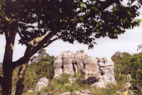
Stone formationsThe second part of the park are the rock formations which gave the park its name - Pa Hin Ngam (ป่าหินงาม) means "forest of beautiful stones". The above mentioned pickups transfer visitors to there, but it is actually not really far so one can walk as well, unlike the way to the cliff it is mostly downhill. The limestone rocks are partially eroded by the millennia of tropical rain, forming this special karst landscape. Some of the rocks have really striking looks with a smaller base than top, and it quite fun to climb around in between them - provided one has good enough shoe and not just the standard flip-flops. As there is only very view trees shadow is rare in this area, so it gets hot quite easily. We were there in the morning hours when then sun was already quite strong, in the afternoon it will probably be unbearable hot.

If Pa Hin Ngam is already too much crowded, similar Siam tulip fields are found in the Sai Thong national park further north within the same mountain range, as recommended by this article in The Nation. Pa Hin Ngam is quite well-promoted, it has even been featured on some beautiful stamps.

One curious thing about the park is the fact that according to the park website at the Department of National Parks it was created in 1994 already, but this hasn't been officially announced in the Royal Gazette until June 2007, when it was published in Volume 124, Issue 26 ก, page 26. (which is however only written in Thai version of the above website).