Most tourists who come to Lopburi will only visit the Khmer temple Prang Sam Yot, with the hordes of monkeys stroling around it. That one is of course a place worth visiting if one is not scared of these animals trying to steal almost everything, especially if its something eatable. When going inside the temple one has a very odd view - the monkeys are behind bars, but actually its the monkeys who are in freedom, and the tourists inside the temple are locked away.
The first time I came to Lopburi - then with a guided tour through the country - we even did not leave the bus as our guide was too scared. I have since returned twice to there, once just taking a closer look at that Prang Sam Yot, but since I want to write about the lesser-known places that other historic site close-by will be the topic.
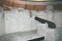
That place is the palace of King Narai the Great, who made Lopburi a second capital after the main capital of Ayutthaya. The palace was built in 1666, and in fact the king stayed there more time than in the real capital. The reign of King Narai is a very interesting part of the Thai history, as it was the time Siam first got into stronger diplomatic relations with the European powers, especially France. There was a French delegation sent to Siam including Count de Forbin, who unsuccessfully tried to convert the King and thus the country to Catholicism. Also very famous was Constantine Phaulkon, a Greek adventurer who became a highly influential counselor of the king. After King Narai died in 1688, the palace was abandoned, the foreign relation were cut off and Phaulkon was sentenced to death by Phetracha, the usurper who became new king then.
The palace was restored in the reign of King Mongkut, including the construction of a new throne hall for his stay in 1856. The building, the Phiman Mongkut Pavilion, later became the first provincial hall of Lopburi. 1924 another pavilion was added, serving as a the Lopburi Museum. This museum is now one of the many branch museums of the National Museum of Thailand. Sadly I haven't visited that museum then, as otherwise we would have to skip the sunflower fields scheduled for the afternoon.
But nevertheless, strolling around within the nicely kept ruins of the palace, and at that time the only visitors within the compound makes it a very worthwhile visit, and a great change from the much busier Prang Sam Yot. The place I liked most was at the old throne hall, where they placed the memorial plate depicting King Narai granting an audience to French ambassadors. As usual with everything related to Thai kings, there are garlands hanged around it, and the picture of the king was covered with gold leaves.
The next time I get a chance to go to Lopburi, the museum is on my list of places to go, and I also want to take a look at the ruins of Phaulkons residence. There are also several old temples within the historic part of the town, so enough to see for at least one more day-trip.
As the reign of King Narai was quite outstanding and the occurrences at his death marked a turning point in the Thai history, many books are published about it, and I own quite a lot of them. Starting from fictional biographies of Phaulkon, the travel reports of Claude de Forbin, and even a small book deviating from the usually quite negative accounts of Phaulkon's activities.
Thursday, December 18, 2008
Tuesday, October 28, 2008
Don Hoi Lot
Don Hoi Lot (ดอนหอยหลอด) is the name of a sandbar at the mouth of Mae Klong river at the town Samut Songkhram. I went there on my first trip to Thailand in 2000, and it was on my last day in the country, so I did not take many photos anymore - already had many films filled, and still not knowing much about the culture the temples and shrines started to look all the same by then. So the only thing I photographed there were some trees in the tidal zone, submerged by the high tide.
The place is a famous for its sea food restaurants, which include those shells which gave their name to the place. Don Hoi Lot means sandbar of the Lot shells, better known as Razor Clam shells (Solen regularis). Lot (หลอด) by itself means (drinking) straw, and thus refers to the shape of these shells, a long narrow tube-like shape. Actually, Lot is also a vulgar term for the female vulva... This endemic shell species was one of the reasons why this sandbar was one of 10 wetlands protected by the Ramsar Convention, inscribed in 2001.
Additional to the nature, there's also a cultural place right at the mouth of the river, the shrine of Prince Chumphon Khet-Udomsak, the father of the Royal Thai Navy. Sadly as mentioned above I did not take any photos of it. But it was hardly to overlook, or better to overhear, as the sound of firecrackers was common during all the time we stayed there. And as I did not know anything on the natural importance of this place, a good seafood meal was all I did back then. Hopefully I can make it there again, and then include a visit on the sandbar itself.
The place is easy to find, just follow the road from Bangkok to Samut Songkhram, and directly before the bridge over the Mae Klong and thus the town Samut Songkram turn into the narrow street to the sea. There's of course also a tourist sign to point to the right exit.
Tuesday, July 15, 2008
Suan Somdet Ya in Bangkok
I mentioned it already earlier, the Somdet Ya park in Bangkok's Khlong San district is also a place worth visiting. It is a bit hidden, I don't recall to have seen any signs on the main road pointing there and it wasn't marked on my map either, so we had to ask our way to there. But actually if you know how the direction it's not difficult to find anymore - after crossing either Memorial Bridge or Pok Klao bridge to the Thonburi side of the town, turn into the next big street to the left, Somdet Chao Phraya road. And directly after the temple Wat Anongkharam Worawihan turn into the small sidestreet to the left, Soi 3. And then just straight on until you see the small parking lot to the left.
As usual at the tourist attractions or other notable locations within Bangkok, there's a brown bilingual sign explaining the location. The English text reads as follows:
As I went there with our then two year old daughter, I was only able to stroll around the park compound, but had to skip the actual museum. But that one is on my list of places I have to revisit in more detail when I get the chance, and then also checking out the two temples at the main street, including the district museum of Khlong San which should be located within one of them.
But the park, even though it is small, has quite some nice views, like a wall overgrown with the roots of a tree, an old well, or the large two sided relief. Too bad I haven't photographed the sign with the description of that relief, so I cannot recall anymore what is the actual meaning of the procession on the one side and the various activities on the other side.
As usual at the tourist attractions or other notable locations within Bangkok, there's a brown bilingual sign explaining the location. The English text reads as follows:
Somdet Phra Sri Nagarindra The Princess Mother Memorial Park
Nearly 100 years ago, a young girl who then daughter of a goldsmith, but would later be Her Royal Highness Sri Nagarindra the Princess Mother, lived in a small rented house behind Wat Anongkaram. This was the first home that she could remember, and a school near Wat Anongkaram was the first school she attended. Her Royal Highness Sri Nagarindra the Princess Mother, who was affectionally called "Princess Grandmother" of the Thai people, remembered in great detail this simple home in a mixed community of several ethnic groups and religious faiths. Her son, His Majesty King Bhumibol Adulyadej, wanted to honor his mother on her eighth 12 years cycle (96th) birthday by preserving her childhood home; but unfortunately the house had long been torn down. Luckily, when Mr. Daeng and Mr. Lek Nana learned of the search for the house, they donated a 4 rai (0.64 ha) plot near the original home. His Majesty King Bhumibol Adulyadej decided in 1993 to renovate this plot, once the home of Chao Phraya Sriphiphat Rattanarakosathibodi (Pae Bunnag), Director General of the Royal Cargo Department during the reign of His Majesty King Rama V, to be the Somdet Phra Sri Nagarindra The Princess Mother Memorial Park. One of the older buildings, from the time of His Majesty King Rama III, has been converted into a museum on the life and work of Her Royal Highness the Princess Mother and on the neighborhood where she first grew up. A replica has also been built of her original childhood house, while the grounds have been developed as a community park where a variety of activities are held for people of all ages of the neighborhood and other visitors.
As I went there with our then two year old daughter, I was only able to stroll around the park compound, but had to skip the actual museum. But that one is on my list of places I have to revisit in more detail when I get the chance, and then also checking out the two temples at the main street, including the district museum of Khlong San which should be located within one of them.
But the park, even though it is small, has quite some nice views, like a wall overgrown with the roots of a tree, an old well, or the large two sided relief. Too bad I haven't photographed the sign with the description of that relief, so I cannot recall anymore what is the actual meaning of the procession on the one side and the various activities on the other side.
Friday, June 6, 2008
Bangkok Noi District Museum
The Bangkok city administration launched a program to have local museums in every of the 50 district of the city some years ago. The one for the district Bangkok Noi is located not that far away from our home in Bangkok, and coincidentally it is the only one the 20 district museums opened so far which was ever featured in English at Tour Bangkok Legacies, so I could easily get the location and opening times - important to note it is closed on Mondays and Tuesdays.
In fact I visited that museum twice already, the first time was maybe two or three years ago with my brother-in-law shortly after I had seen that recommendation, and I revisited it in April this year to see if I can get more of it this time, and most of all to take photos. Originally I planned to visit other district museums as well, but as usual in vacation time ran out so fast, and I only made it to this one on my last day in Bangkok when I could finally do a little walking tour around Bangkok Noi.
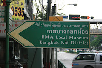
The museum is located in a room of the Suwannaram Witthayakhom school, not far from the district office of Bangkok Noi. It is quite easy to find, there are signs pointing towards it at the Bang Khun Non intersection on Charan Sanitwong Road, near the bridge over Khlong Bangkok Noi. Not far after the intersection the school is to the left, impossible to miss due to a large blue billboard announcing the museum. When you enter the school yard, the museum entrance is at the building to the left.
There is always at least one clerk sitting at the entrance, but sadly they only speak Thai so foreigners have to do a self-guided tour - for Thai visitors they are very happy to explain everything in detail. But as almost all texts at the exhibits are bilingual Thai-English it's easy to get at least a good glimpse on the history and traditions of the district.
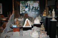
Additionally to the text signs with the histories of the district or the important places, there are exhibits for the traditional industries of the area. I have added the photos for two of them - the production of Matum (มะตูม), the bael fruit boiled in syrup to make it a special snack. Another business still present in the district is the casting of Buddha images. Further exhibits are on the production of stone-polished bowls, and the production of another kind of sweet snack, created from roasted rice.
Though the museum is not large, it is worth a visit if you are in the area. And it really deserves more visitors, when I went there I was the first person of the day to sign the guestbook, and the first one for nearly two weeks (the Songkran holiday week was one of it, that can explain the low number a bit). I guess I could say the same about the other district museums, though I haven't yet visited any other one. The city really should make that program more public, the only thing way one learns about it are the signs in the street, the website of the program is hard to find and in Thai only.
Wednesday, May 21, 2008
Beach at Khanom
As there is no real beach around the town Surat Thani, the nearest place for a day at the beach is in Khanom district in neighboring Nakhon Si Thammarat province. I went there three times already, as when staying in Thailand at least some time at the beach simply belongs to the itinerary. What I like at the beach in Khanom is that they are still quite unknown to foreign tourists, who all are found on Ko Samui - which also has great sandy beaches, but to me is way to crowded already.
Along the beach there are many small resorts which often include a restaurant, as for Thai tourists traveling usually means eating at a different location. Of course having fresh seafood directly at the beach is something I enjoy as well. The last two times we went to the Nai Pet beach (หาดในเปร์ต), this time we went a bit further south to Nai Plao beach (หาดในเพลา) and stayed at the only hotel of the whole area, the Supar (sic!) Royal Beach Hotel. Nai Plao beach is much shorter than the the Nai Phet, the two are separated by a small group of rocks which make a really beautiful view.
The beach is reasonably clean, inevitably there is some garbage left by careless people but most of the non-natural stuff washed ashore is styrofoam torn off from the fishing nets. But to be honest I had to look a bit to find that long stretch of garbage in the photo. The sand is fine, some shells can be found as well, though most are already broken. Last time I also saw several eremite crabs walking on the beach, the one I successfully photographed however was already dead as that one did not run away from my camera before I could focus it well.
Thursday, May 15, 2008
Suan Somdet Ya in Cha-Am
Somewhat outside of the town Cha-Am is one of the several Somdet Ya parks (สวนสมเด็จย่าฯ) which exist around Thailand. In fact, there are at least three kinds of parks named after the mother of HM King Bhumipol. The first one is the historical park in Khlong San district of Bangkok around the birthplace of the princess mother - a place I plan to feature here later as well. Then there are several recreational parks named after her, for example the one in Nonthaburi province near Mueang Thong Thani. The one in Cha-Am district is of another kind, an educational park. The full name is สวนสมเด็จพระศรีนครินทราบรมราชชนนี, Suan Somdet Srinagarindra Boromarajajonani, the full ceremonial name of the princess mother, and is operated by the Chaipattana Foundation.
The park is located between Cha-Am and Hua Hin, west of the Phetkasem highway bypass on road 1001 leading towards the Springfield Village resort. Directly before the Huai Ta Paet reservoir the large sign "Welcome to Suan Somdet Ya" is nearly impossible to miss, there turn to the right and maybe 50 meters inside that road is the entrance. The area has just now become visible in hires in Google Earth, which will come into the WikiMapia view of the place soon as well.
Both days we stayed near there I have seen several buses parking at the entrance, bringing school kids to the park. Inside the park it has several outdoor school rooms - open huts with lots of chairs. And it is probably this way to get most of this park, as there are hardly any descriptive signs on the exhibits, so without a guided tour one hardly gets anything from this park. Only within the herbs garden it has signs with the names of the plants, and their medic effects. The fields with various vegetables or fruits grown for either display or agricultural techniques or for experimentation come without any signs, so I can only suspect it is these two purposes of them. If looking for scenic places within the park it is really not the place to go, the only thing scenic is the fountain at the pond right at the entrance, or a few views within the herb garden.
Thursday, February 28, 2008
King Rama II Memorial Park
King Rama II, posthumously named Buddha Loetla Nabhalai, was the second King of the Chakri dynasty, the royal dynasty still ruling in Thailand today. He was born on February 24 1767 in Amphawa, next to the temple Wat Amphawan Chetiyaram. To commemorate the place, a park was established at that place adjoining the temple, built on land donated from the temple.
The park is located on highway 6006, which branches off from 325 in Amphawa town. We came there from the Ratchaburi Cathedral, which is also on the 6006, but it already had become rather late, just 30 minutes before the park was supposed to get closed. So I only had time for a stroll through the park till the Mae Khlong river, and return to the car, but no time to see the exhibitions inside the buildings built in the historical style. Just had the time to take photos of the various parts of the park, which additional to these houses also contain a ship used by a later King, and also several statues within a pond. Too bad I don't know which stories are the basis of these statues, but wouldn't be surprised if it is one of the nirats of Sunthorn Phu.
Nearby is also the Amphawa floating market, much less commercial and touristical than the famous one at Damnoen Saduak.
Wednesday, February 20, 2008
Mermaid in Songkhla
Everyone knows the mermaid statue in Kopenhagen, but the one in Songkhla has become a local tourist attraction already as well. It is located at the northeastern tip of the peninsula which contains the city of Songkhla, at the Samila beach.
Of course the statue does not depict the mermaid from Hans Christian Andersens fairytale, but a character from the tale Phra Apaimanee by Sonthorn Phu. The statue was created in 1966 by Jitr Buabus, director of the Art & Craft College, Bangkok.
This beach has quite a lot of statues. A little bit west of the mermaid is a statue of a cat and a mouse, which refers to the name of two islands off the coast named cat and mouse island. It look especially nice when seen through that gate, which is kind of an entrance to the beach.
South of the mermaid at the circle ending of the street is a statue of a reading man. I have no idea what is the meaning of that one, as unlike the mermaid it had no English description on the plate next to it, and at the time we went there my knowledge of the Thai letters was also almost zero so I could not write down the name of the statue either.
Location:
Unknown location
Monday, February 11, 2008
Rafflesia in Khao Sok
The Khao Sok national park (อุทยานแห่งชาติเขาสก) is not really a place I can call "unseen", as it is the most popular national park in southern Thailand. Given it's location not far from the touristic centers on Phuket or at Khao Lak, it is an easy target for day tours from these places for tourists tired of spending all day at the beach. But even though foreigners are nothing uncommon there, it is not overcrowded with them and still worth the visit.
The park is accessible in two parts. The first one is the Ratchaprapha dam, which created the Chiao Lan lake. Especially this dam is popular for Thai tourist, so I already went there twice, the first time doing a picnic there and then later do a boat trip over the lake to the fascinating cliffs partially submerged in the artificial lake. The second time we just did the boating, as the dam itself was already overcrowded with Thai people celebrating Songkhran (Thai New Year) there.
The second part around the visitor center of the park has several jungle trails, however I did not do any of those yet. This is because I most wanted to see the most peculiar flower of Thailand, the Rafflesia. It is a parasitic plant living within the roots of a tree, with only their buds and flowers being visible. While this is interesting already, the mere size of the flowers - reaching one meter in diameter - makes them really extraordinary. I wanted to see this flower in real ever since I first read about it, but either we had no time while we were in Surat Thani, or it had no flower in blooming then. So when we went to the visitor center and learned that there is a Rafflesia blooming, we quite quickly decided to go to that place instead of taking the trails.
The blooming was actually not within the park itself, but on private land slightly outside the park boundaries. The hiking began at the house of the rubber farmer who owns the land, and after a short walking through the rubber trees we entered the jungle already. I have no idea how far it really was, but it was quite tiring to walk uphill in the hot weather with just on bottle of water. But it was well worth it, as it was not just a single flower in full blooming, but it also had two older ones in various parts of decomposing, and also new buds which were about to bloom soon. So I could not only take close-up photos of this fascinating flower, but could get the whole development from bud to decomposing flower in one time. The only thing which lacked was the smell - normally Rafflesia has a smell of rotten meat to attract the flies to do the pollinating. But that one had almost no smell at all, but even without smell there were a few flies inside it. The full set of these photos I have uploaded to flickr.
Seeing the flower in real did only create more interest into these flowers, so I got myself the book "Rafflesia of the world" by Jamili Nais - the only online shop which has it for reasonable price was borneobooks. I learned a lot more about these plants from that book, so I am looking forward to see the new book mentioned in the Rafflesia blog.
The park is accessible in two parts. The first one is the Ratchaprapha dam, which created the Chiao Lan lake. Especially this dam is popular for Thai tourist, so I already went there twice, the first time doing a picnic there and then later do a boat trip over the lake to the fascinating cliffs partially submerged in the artificial lake. The second time we just did the boating, as the dam itself was already overcrowded with Thai people celebrating Songkhran (Thai New Year) there.
The second part around the visitor center of the park has several jungle trails, however I did not do any of those yet. This is because I most wanted to see the most peculiar flower of Thailand, the Rafflesia. It is a parasitic plant living within the roots of a tree, with only their buds and flowers being visible. While this is interesting already, the mere size of the flowers - reaching one meter in diameter - makes them really extraordinary. I wanted to see this flower in real ever since I first read about it, but either we had no time while we were in Surat Thani, or it had no flower in blooming then. So when we went to the visitor center and learned that there is a Rafflesia blooming, we quite quickly decided to go to that place instead of taking the trails.
The blooming was actually not within the park itself, but on private land slightly outside the park boundaries. The hiking began at the house of the rubber farmer who owns the land, and after a short walking through the rubber trees we entered the jungle already. I have no idea how far it really was, but it was quite tiring to walk uphill in the hot weather with just on bottle of water. But it was well worth it, as it was not just a single flower in full blooming, but it also had two older ones in various parts of decomposing, and also new buds which were about to bloom soon. So I could not only take close-up photos of this fascinating flower, but could get the whole development from bud to decomposing flower in one time. The only thing which lacked was the smell - normally Rafflesia has a smell of rotten meat to attract the flies to do the pollinating. But that one had almost no smell at all, but even without smell there were a few flies inside it. The full set of these photos I have uploaded to flickr.
Seeing the flower in real did only create more interest into these flowers, so I got myself the book "Rafflesia of the world" by Jamili Nais - the only online shop which has it for reasonable price was borneobooks. I learned a lot more about these plants from that book, so I am looking forward to see the new book mentioned in the Rafflesia blog.
Tuesday, January 29, 2008
Pa Hin Ngam National Park
Pa Hin Ngam national park (อุทยานแห่งชาติป่าหินงาม) is a relative new park located in the southwest of Chaiyaphum Province. The park is most famous for the blossoming of the Siam Tulip (Curcuma alismatifolia, in Thai กระเจียว) at begin of the raining season in July.
As it is most convenient to walk around in the cool morning hours, we hired a minibus to bring us from Bangkok to the park overnight, and after arriving at a campground we had some hours of sleep as well. Just after sunrise the campground has become completely filled, so there was quite some queue at the pickups to bring the visitors uphill to the tulip fields. When we left the park around lunch time, it became clear it was a good idea to drive overnight, as for several kilometers it had cars queued who did not make it to the cap ground yet, and it of course also got quite hot already.
The Siam tulip fields are on the meadows near the cliff, fittingly named Sut Phan Din (สุดแผ่นดิน), end of land. The cliff, which also forms the watershed between the Chao Phraya river system and the Isan plateau which drains into the Mekong, offers a great view into the valley of the Sonthi river, an small tributary of the Pasak, which mouths into the Chao Phraya in Ayutthaya. The cliff is at an elevation of 846 m above sea level. The photo shows the view from the cliff to the hills of the next mountain chain of the other side of the Sonthi river. The forests partially covered in morning mist are protected as the Sap Langka wildlife sanctuary.
The meadows with the Siam Tulip are crisscrossed with elevated wooden walkways, so one can get easily in the middle of the beautiful flowers without having them trampled down by the thousands of visitors - almost exclusively Thai people. The Siam tulip actually is not a tulip, but is related with the ginger plant.
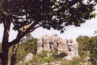
The second part of the park are the rock formations which gave the park its name - Pa Hin Ngam (ป่าหินงาม) means "forest of beautiful stones". The above mentioned pickups transfer visitors to there, but it is actually not really far so one can walk as well, unlike the way to the cliff it is mostly downhill. The limestone rocks are partially eroded by the millennia of tropical rain, forming this special karst landscape. Some of the rocks have really striking looks with a smaller base than top, and it quite fun to climb around in between them - provided one has good enough shoe and not just the standard flip-flops. As there is only very view trees shadow is rare in this area, so it gets hot quite easily. We were there in the morning hours when then sun was already quite strong, in the afternoon it will probably be unbearable hot.
If Pa Hin Ngam is already too much crowded, similar Siam tulip fields are found in the Sai Thong national park further north within the same mountain range, as recommended by this article in The Nation. Pa Hin Ngam is quite well-promoted, it has even been featured on some beautiful stamps.
One curious thing about the park is the fact that according to the park website at the Department of National Parks it was created in 1994 already, but this hasn't been officially announced in the Royal Gazette until June 2007, when it was published in Volume 124, Issue 26 ก, page 26. (which is however only written in Thai version of the above website).
Tuesday, January 22, 2008
Wat Rong Khun
After leaving Mae Sai it was already late afternoon, so we arrived at the extraordinary tempe Wat Rong Khun (วัดร่องขุ่น) just shortly before it was closed for the day. I had never heard anything about the Thai artist Chalermchai Kositpipat before, so when hurrying through the gallery next to the temple before it was closed at 5 PM I did not get much about his art either. But that is no wonder, as I still don't know much about Thai Buddhism nor the Thai art. Anyway, even for a ignorant farang the temple is very impressive, and it's no wonder it is becoming a tourist attraction of Chiang Rai now.
The temple is located on Thai highway 1, on the way from the city Chiang Rai towards the south, about 10 km from the city. Exit at the intersection with road 1208. The temple is just a few metres away from the intersection, quite impossible to miss the striking white ornate building if you have taken the right exit from the main highway.
When we visited the place in 2006, the temple already looked nearly finished, at least the whole front part was complete, and construction was limited to the sides and behind of the central room holding the Buddha image - unlike normal temples it is actually a huge Buddha painting with only small statue in front. But already when you enter the temple over the bridge, the corpses in the water under the bridge are something never seen in Buddhist temples. But I guess to fully get all the symbolism within the building one has to find a book explaining all about it, but there was nothing like that in English in the souvenir shop. Maybe after the temple will be finished this year it will have someone bother to write something for those who cannot read Thai.
While I was strolling around the place, I was suddenly called to pose for a family photo - somehow someone from family caught the artist himself, and apparently he didn't mind to pose with us. Pity I did not know his importance then, otherwise I would have tried to do a portrait photo for Wikipedia as well.
Saturday, January 5, 2008
Chet Khot-Pong Kon Sao Nature Study Centre
The Chet Khot-Pong Kon Sao Nature Study Centre is a park in the east of Saraburi Province, not far from the Khao Yai national park. Though usually referred to as a "Forest Park", it is not under the supervision of the National Park Division like the other forest parks. The park was created in 2000 by the agriculture minister Pongpol Adireksarn.
The park is easy to reach, just follow the sign from Highway 2 (westwards) and turn to the left, and after about 20 km you reach a small reservoir. Turn to the left, and then the entrance is to the left shortly - directly before you arrive the boy scout camp. After the checkpoint it's another few kilometers steep uphill until you reach the visitor center. Next to the visitors center are several beautiful huts for rent, including fridge and oven - but bring a towel with you, at least when we stayed there it did not have any provided.
We only stayed there for one night, so there was not much time to hike into the forests, and to make it worse we came in the height of the dry season, so the waterfall was reduced to not much more than the water in a standard shower. And when I reached one of the waterfalls it was already near sunset, and the light was too low to do any good photos. Only in the scaled down version one does not notice it being very blurred due to the longer exposure. A second trail I took in the morning did not lead me far, but an interesting sight were the remains of a house already overgrown by the jungle again. Only the concrete foundations were still visible.
I want to come to this park again for sure, then staying at least one day to have the chance to see not just one, but all the tiers that brook forms in the valley, and also see and photograph them in their full beauty.
At least the garden and camp ground at the reservoir next to the huts gave me opportunity to take some scenic photographs, but I prefer to scenery created by nature itself.
Another report on the park I found at thailandtraveltours.com.
Subscribe to:
Posts (Atom)