 Pa Hin Ngam national park (อุทยานแห่งชาติป่าหินงาม) is a relative new park located in the southwest of Chaiyaphum Province. The park is most famous for the blossoming of the Siam Tulip (Curcuma alismatifolia, in Thai กระเจียว) at begin of the raining season in July.
 As it is most convenient to walk around in the cool morning hours, we hired a minibus to bring us from Bangkok to the park overnight, and after arriving at a campground we had some hours of sleep as well. Just after sunrise the campground has become completely filled, so there was quite some queue at the pickups to bring the visitors uphill to the tulip fields. When we left the park around lunch time, it became clear it was a good idea to drive overnight, as for several kilometers it had cars queued who did not make it to the cap ground yet, and it of course also got quite hot already.
 The Siam tulip fields are on the meadows near the cliff, fittingly named Sut Phan Din (สุดแผ่นดิน), end of land. The cliff, which also forms the watershed between the Chao Phraya river system and the Isan plateau which drains into the Mekong, offers a great view into the valley of the Sonthi river, an small tributary of the Pasak, which mouths into the Chao Phraya in Ayutthaya. The cliff is at an elevation of 846 m above sea level. The photo shows the view from the cliff to the hills of the next mountain chain of the other side of the Sonthi river. The forests partially covered in morning mist are protected as the Sap Langka wildlife sanctuary.
 The meadows with the Siam Tulip are crisscrossed with elevated wooden walkways, so one can get easily in the middle of the beautiful flowers without having them trampled down by the thousands of visitors - almost exclusively Thai people. The Siam tulip actually is not a tulip, but is related with the ginger plant.
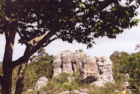 The second part of the park are the rock formations which gave the park its name - Pa Hin Ngam (ป่าหินงาม) means "forest of beautiful stones". The above mentioned pickups transfer visitors to there, but it is actually not really far so one can walk as well, unlike the way to the cliff it is mostly downhill. The limestone rocks are partially eroded by the millennia of tropical rain, forming this special karst landscape. Some of the rocks have really striking looks with a smaller base than top, and it quite fun to climb around in between them - provided one has good enough shoe and not just the standard flip-flops. As there is only very view trees shadow is rare in this area, so it gets hot quite easily. We were there in the morning hours when then sun was already quite strong, in the afternoon it will probably be unbearable hot.
 If Pa Hin Ngam is already too much crowded, similar Siam tulip fields are found in the Sai Thong national park further north within the same mountain range, as recommended by this article in The Nation. Pa Hin Ngam is quite well-promoted, it has even been featured on some beautiful stamps.
One curious thing about the park is the fact that according to the park website at the Department of National Parks it was created in 1994 already, but this hasn't been officially announced in the Royal Gazette until June 2007, when it was published in Volume 124, Issue 26 ก, page 26. (which is however only written in Thai version of the above website).


 Subscribe to RSS feed
 Subscribe by EMail
